
Thank you for supporting this site ❤️
Make a donation
Make a donation
Haren topographic map
Click on the map to display elevation.
Thank you for supporting this site ❤️
Make a donation
Make a donation
About this map
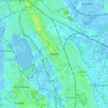
Name: Haren topographic map, elevation, terrain.
Location: Haren, Groningen, Nederland, 9752BT, Nederland (53.13087 6.56609 53.21087 6.64609)
Average elevation: 2 m
Minimum elevation: -5 m
Maximum elevation: 12 m
Thank you for supporting this site ❤️
Make a donation
Make a donation
Other topographic maps
Click on a map to view its topography, its elevation and its terrain.