
Gries-Quirein topographic map
Interactive map
Click on the map to display elevation.
About this map
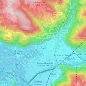
Name: Gries-Quirein topographic map, elevation, terrain.
Location: Gries-Quirein, Bozen, Trentino-Südtirol, Italien (46.48337 11.27539 46.53038 11.36418)
Average elevation: 566 m
Minimum elevation: 229 m
Maximum elevation: 1,282 m
Other topographic maps
Click on a map to view its topography, its elevation and its terrain.