
Toronto topographic map
Interactive map
Click on the map to display elevation.
About this map
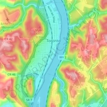
Name: Toronto topographic map, elevation, terrain.
Location: Toronto, Jefferson County, Ohio, United States (40.43647 -80.62282 40.48325 -80.59620)
Average elevation: 277 m
Minimum elevation: 198 m
Maximum elevation: 379 m
Other topographic maps
Click on a map to view its topography, its elevation and its terrain.
Richmond
United States > Ohio > Jefferson County
Richmond, Jefferson County, Ohio, 43944, United States
Average elevation: 364 m
Adena
United States > Ohio > Jefferson County
Adena, Jefferson County, Ohio, United States
Average elevation: 310 m
Tiltonsville
United States > Ohio > Jefferson County
Tiltonsville, Jefferson County, Ohio, 43963, United States
Average elevation: 251 m
Beechwood
United States > Ohio > Jefferson County > Wintersville
Beechwood, Wintersville, Jefferson County, Ohio, 43953, United States
Average elevation: 348 m
Wolf Run
United States > Ohio > Jefferson County
Wolf Run, Jefferson County, Ohio, 43970, United States
Average elevation: 359 m
Steubenville
United States > Ohio > Jefferson County
Steubenville, Jefferson County, Ohio, 43952, United States
Average elevation: 296 m
La Belle
United States > Ohio > Jefferson County > Steubenville
La Belle, Steubenville, Jefferson County, Ohio, 43952, United States
Average elevation: 267 m
Green Acres
United States > Ohio > Jefferson County
Green Acres, Jefferson County, Ohio, 43953, United States
Average elevation: 327 m
Bloomingdale
United States > Ohio > Jefferson County
Bloomingdale, Jefferson County, Ohio, United States
Average elevation: 357 m
Wintersville
United States > Ohio > Jefferson County
Wintersville, Jefferson County, Ohio, 43953, United States
Average elevation: 346 m
Irondale
United States > Ohio > Jefferson County > Irondale
Irondale, Jefferson County, Ohio, United States
Average elevation: 308 m