
Alost topographic map
Interactive map
Click on the map to display elevation.
About this map
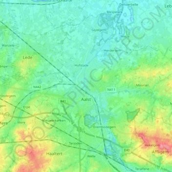
Name: Alost topographic map, elevation, terrain.
Location: Alost, Aalst, Flandre orientale, Flandre, Belgique (50.89938 3.98245 50.99483 4.16343)
Average elevation: 20 m
Minimum elevation: 0 m
Maximum elevation: 78 m
Other topographic maps
Click on a map to view its topography, its elevation and its terrain.
Zarlardinge
Belgique > Flandre orientale > Aalst > Grammont
Zarlardinge, Grammont, Aalst, Flandre orientale, 7863, Belgique
Average elevation: 42 m
Ninove
Belgique > Flandre orientale > Aalst
Ninove, Aalst, Flandre orientale, Belgique
Average elevation: 36 m
Sint-Antelinks
Belgique > Flandre orientale > Aalst
Sint-Antelinks, Herzele, Aalst, Flandre orientale, Flandre, Belgique
Average elevation: 56 m
Grammont
Belgique > Flandre orientale > Aalst
Grammont, Aalst, Flandre orientale, Flandre, Belgique
Average elevation: 40 m