
Trafford topographic map
Interactive map
Click on the map to display elevation.
About this map
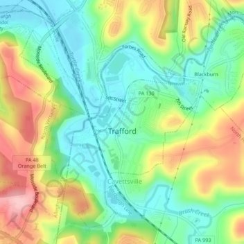
Name: Trafford topographic map, elevation, terrain.
Location: Trafford, Westmoreland County, Pennsylvania, United States (40.36956 -79.77502 40.39695 -79.73349)
Average elevation: 293 m
Minimum elevation: 229 m
Maximum elevation: 397 m
Other topographic maps
Click on a map to view its topography, its elevation and its terrain.
Collinsburg
United States > Pennsylvania > Westmoreland County > Rostraver Township
Collinsburg, Rostraver Township, Westmoreland County, Pennsylvania, 15089, United States
Average elevation: 282 m
Painter Rock Hill
United States > Pennsylvania > Westmoreland County > Donegal Township
Painter Rock Hill, Donegal Township, Westmoreland County, Pennsylvania, 15502, United States
Average elevation: 781 m
Unity Township
United States > Pennsylvania > Westmoreland County
Unity Township, Westmoreland County, Pennsylvania, United States
Average elevation: 375 m
Washington Township
United States > Pennsylvania > Westmoreland County
Washington Township, Westmoreland County, Pennsylvania, 15613, United States
Average elevation: 358 m
Greensburg
United States > Pennsylvania > Westmoreland County
Greensburg, Westmoreland County, Pennsylvania, 15601, United States
Average elevation: 353 m
North Huntingdon Township
United States > Pennsylvania > Westmoreland County > North Huntingdon Township
North Huntingdon Township, Westmoreland County, Pennsylvania, United States
Average elevation: 325 m
Yukon
United States > Pennsylvania > Westmoreland County > South Huntingdon Township
Yukon, South Huntingdon Township, Westmoreland County, Pennsylvania, 15698, United States
Average elevation: 315 m
Penn Township
United States > Pennsylvania > Westmoreland County
Penn Township, Westmoreland County, Pennsylvania, United States
Average elevation: 346 m
Keystone State Park
United States > Pennsylvania > Westmoreland County > Derry Township
Keystone State Park, Derry Township, Westmoreland County, Pennsylvania, United States
Average elevation: 352 m
Superior
United States > Pennsylvania > Westmoreland County > Derry Township
Superior, Derry Township, Westmoreland County, Pennsylvania, 15671, United States
Average elevation: 356 m
Hempfield Township
United States > Pennsylvania > Westmoreland County > Hempfield Township
Hempfield Township, Westmoreland County, Pennsylvania, United States
Average elevation: 340 m
Camp Jo-Ann
United States > Pennsylvania > Westmoreland County > Murrysville > Camp Jo-Ann
Camp Jo-Ann, Murrysville, Westmoreland County, Pennsylvania, United States
Average elevation: 343 m
Bessemer
United States > Pennsylvania > Westmoreland County > East Huntingdon Township > Bessemer
Bessemer, East Huntingdon Township, Westmoreland County, Pennsylvania, 15666, United States
Average elevation: 342 m
Salem Township
United States > Pennsylvania > Westmoreland County > Salem Township
Salem Township, Westmoreland County, Pennsylvania, United States
Average elevation: 356 m
Delmont
United States > Pennsylvania > Westmoreland County > Delmont
Delmont, Westmoreland County, Pennsylvania, 15626, United States
Average elevation: 374 m
Scottdale
United States > Pennsylvania > Westmoreland County > Scottdale
Scottdale, Westmoreland County, Pennsylvania, 15683, United States
Average elevation: 337 m
Maplewood Terrace
United States > Pennsylvania > Westmoreland County > Hempfield Township > Maplewood Terrace
Maplewood Terrace, Hempfield Township, Westmoreland County, Pennsylvania, 15601, United States
Average elevation: 346 m
Murrysville
United States > Pennsylvania > Westmoreland County
Murrysville, Westmoreland County, Pennsylvania, 15668, United States
Average elevation: 344 m
New Kensington
United States > Pennsylvania > Westmoreland County
New Kensington, Westmoreland County, Pennsylvania, 15068, United States
Average elevation: 287 m
North Belle Vernon
United States > Pennsylvania > Westmoreland County
North Belle Vernon, Westmoreland County, Pennsylvania, United States
Average elevation: 285 m