
Ouled Tebben topographic map
Interactive map
Click on the map to display elevation.
About this map
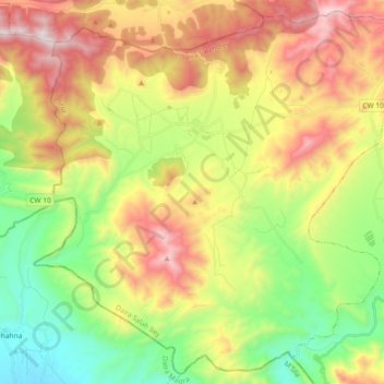
Name: Ouled Tebben topographic map, elevation, terrain.
Location: Ouled Tebben, Daïra Salah Bey, Sétif, Algérie (35.71763 5.02408 35.85869 5.20797)
Average elevation: 1,185 m
Minimum elevation: 695 m
Maximum elevation: 1,837 m
Other topographic maps
Click on a map to view its topography, its elevation and its terrain.
Hamma
Algérie > Sétif > Daïra Salah Bey
Hamma, Daïra Salah Bey, Sétif, 19015, Algérie
Average elevation: 1,061 m