
Vega de Pas topographic map
Interactive map
Click on the map to display elevation.
About this map
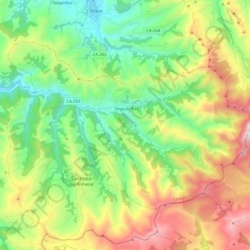
Name: Vega de Pas topographic map, elevation, terrain.
Average elevation: 741 m
Minimum elevation: 208 m
Maximum elevation: 1,682 m
Other topographic maps
Click on a map to view its topography, its elevation and its terrain.
Hornedillo
Espagne > Cantabria > Valles Pasiegos > San Pedro del Romeral
Hornedillo, San Pedro del Romeral, Valles Pasiegos, Cantabria, Cantabrie, 39686, Espagne
Average elevation: 491 m
San Pedro del Romeral
Espagne > Cantabria > Valles Pasiegos
San Pedro del Romeral, Valles Pasiegos, Cantabria, Cantabrie, Espagne
Average elevation: 682 m