
Evans topographic map
Interactive map
Click on the map to display elevation.
About this map
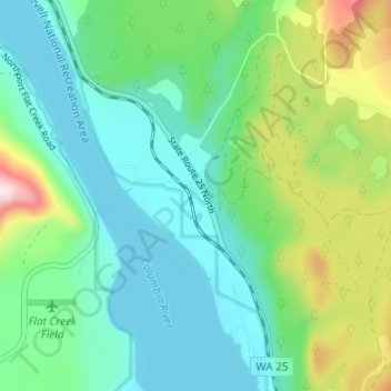
Name: Evans topographic map, elevation, terrain.
Location: Evans, Stevens County, Washington, 99126, United States (48.69352 -118.04527 48.73352 -118.00527)
Average elevation: 487 m
Minimum elevation: 382 m
Maximum elevation: 783 m
Other topographic maps
Click on a map to view its topography, its elevation and its terrain.
Mount Rogers
United States > Washington > Stevens County
Mount Rogers, Stevens County, Washington, United States
Average elevation: 1,437 m
Spokane Indian Reservation
United States > Washington > Stevens County
Spokane Indian Reservation, Stevens County, Washington, 99040, United States
Average elevation: 713 m
Ford
United States > Washington > Stevens County
Ford, Stevens County, Washington, United States
Average elevation: 577 m
Wellpinit
United States > Washington > Stevens County
Wellpinit, Stevens County, Washington, 99040, United States
Average elevation: 762 m
Loon Lake
United States > Washington > Stevens County
Loon Lake, Stevens County, Washington, 99148, United States
Average elevation: 751 m
Rice
United States > Washington > Stevens County
Rice, Stevens County, Washington, 99167, United States
Average elevation: 536 m
Camas
United States > Washington > Stevens County
Camas, Stevens County, Washington, United States
Average elevation: 706 m
Kettle Falls
United States > Washington > Stevens County
Kettle Falls, Stevens County, Washington, 99141, United States
Average elevation: 509 m
Springdale
United States > Washington > Stevens County
Springdale, Stevens County, Washington, United States
Average elevation: 656 m
Lake Roosevelt
United States > Washington > Stevens County
Lake Roosevelt, Stevens County, Washington, United States
Average elevation: 903 m
Colville
United States > Washington > Stevens County
Colville, Stevens County, Washington, United States
Average elevation: 559 m
Chewelah
United States > Washington > Stevens County
Chewelah, Stevens County, Washington, United States
Average elevation: 590 m
Boundary
United States > Washington > Stevens County > Boundary
Boundary, Stevens County, Washington, United States
Average elevation: 611 m
Chewelah
United States > Washington > Stevens County > Chewelah > Chewelah
Chewelah, Stevens County, Washington, United States
Average elevation: 611 m
Northport
United States > Washington > Stevens County > Northport
Northport, Stevens County, Washington, United States
Average elevation: 502 m
Colville
United States > Washington > Stevens County > Colville > Colville
Colville, Stevens County, Washington, United States
Average elevation: 602 m