
Marseille topographic map
Interactive map
Click on the map to display elevation.
About this map
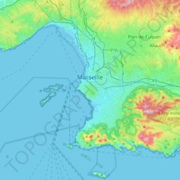
Name: Marseille topographic map, elevation, terrain.
Average elevation: 94 m
Minimum elevation: -5 m
Maximum elevation: 637 m
Other topographic maps
Click on a map to view its topography, its elevation and its terrain.
Cassis
Frankreich > Provence-Alpes-Côte d'Azur > Bouches-du-Rhône > Cassis
Cassis, Marseille, Bouches-du-Rhône, Provence-Alpes-Côte d'Azur, Metropolitanes Frankreich, 13260, Frankreich
Average elevation: 150 m