
Marklesburg topographic map
Interactive map
Click on the map to display elevation.
About this map
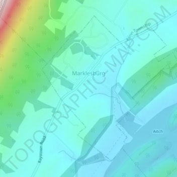
Name: Marklesburg topographic map, elevation, terrain.
Location: Marklesburg, Huntingdon County, Pennsylvania, United States (40.36970 -78.18245 40.39187 -78.15421)
Average elevation: 306 m
Minimum elevation: 236 m
Maximum elevation: 666 m
Other topographic maps
Click on a map to view its topography, its elevation and its terrain.
Three Springs
United States > Pennsylvania > Huntingdon County
Three Springs, Huntingdon County, Pennsylvania, United States
Average elevation: 274 m
Saltillo
United States > Pennsylvania > Huntingdon County
Saltillo, Huntingdon County, Pennsylvania, 17253, United States
Average elevation: 322 m
Robertsdale
United States > Pennsylvania > Huntingdon County > Wood Township
Robertsdale, Wood Township, Huntingdon County, Pennsylvania, 16654, United States
Average elevation: 591 m
Hesston
United States > Pennsylvania > Huntingdon County > Penn Township
Hesston, Penn Township, Huntingdon County, Pennsylvania, United States
Average elevation: 287 m
Orbisonia
United States > Pennsylvania > Huntingdon County
Orbisonia, Huntingdon County, Pennsylvania, United States
Average elevation: 232 m
Alexandria
United States > Pennsylvania > Huntingdon County
Alexandria, Huntingdon County, Pennsylvania, United States
Average elevation: 238 m
Shirleysburg
United States > Pennsylvania > Huntingdon County
Shirleysburg, Huntingdon County, Pennsylvania, United States
Average elevation: 209 m
Spruce Creek
United States > Pennsylvania > Huntingdon County > Spruce Creek Township
Spruce Creek, Spruce Creek Township, Huntingdon County, Pennsylvania, 16683, United States
Average elevation: 329 m
Mapleton
United States > Pennsylvania > Huntingdon County
Mapleton, Huntingdon County, Pennsylvania, United States
Average elevation: 258 m
Pennsylvania Furnace
United States > Pennsylvania > Huntingdon County > Franklin Township
Pennsylvania Furnace, Franklin Township, Huntingdon County, Pennsylvania, United States
Average elevation: 363 m
Coalmont
United States > Pennsylvania > Huntingdon County
Coalmont, Huntingdon County, Pennsylvania, United States
Average elevation: 435 m
Broad Top City
United States > Pennsylvania > Huntingdon County
Broad Top City, Huntingdon County, Pennsylvania, 16621, United States
Average elevation: 602 m
Nossville
United States > Pennsylvania > Huntingdon County > Tell Township
Nossville, Tell Township, Huntingdon County, Pennsylvania, United States
Average elevation: 341 m
Puttstown
United States > Pennsylvania > Huntingdon County > Hopewell Township
Puttstown, Hopewell Township, Huntingdon County, Pennsylvania, 16678, United States
Average elevation: 330 m
Warriors Mark
United States > Pennsylvania > Huntingdon County > Warriors Mark Township
Warriors Mark, Warriors Mark Township, Huntingdon County, Pennsylvania, United States
Average elevation: 370 m
Blairs Mills
United States > Pennsylvania > Huntingdon County > Tell Township
Blairs Mills, Tell Township, Huntingdon County, Pennsylvania, 17213, United States
Average elevation: 283 m
Dudley
United States > Pennsylvania > Huntingdon County
Dudley, Huntingdon County, Pennsylvania, 16634, United States
Average elevation: 486 m
Neelyton
United States > Pennsylvania > Huntingdon County > Dublin Township
Neelyton, Dublin Township, Huntingdon County, Pennsylvania, 17239, United States
Average elevation: 360 m
Todd
United States > Pennsylvania > Huntingdon County > Todd Township
Todd, Todd Township, Huntingdon County, Pennsylvania, 16685, United States
Average elevation: 378 m
Rockhill
United States > Pennsylvania > Huntingdon County
Rockhill, Huntingdon County, Pennsylvania, 17249, United States
Average elevation: 219 m
Mill Creek
United States > Pennsylvania > Huntingdon County
Mill Creek, Huntingdon County, Pennsylvania, United States
Average elevation: 239 m
Birmingham
United States > Pennsylvania > Huntingdon County
Birmingham, Huntingdon County, Pennsylvania, United States
Average elevation: 346 m
Donation
United States > Pennsylvania > Huntingdon County > Oneida Township
Donation, Oneida Township, Huntingdon County, Pennsylvania, United States
Average elevation: 274 m
McAlevys Fort
United States > Pennsylvania > Huntingdon County > Jackson Township
McAlevys Fort, Jackson Township, Huntingdon County, Pennsylvania, United States
Average elevation: 265 m
Saulsburg
United States > Pennsylvania > Huntingdon County > Barree Township
Saulsburg, Barree Township, Huntingdon County, Pennsylvania, United States
Average elevation: 303 m
Aitch
United States > Pennsylvania > Huntingdon County > Penn Township
Aitch, Penn Township, Huntingdon County, Pennsylvania, United States
Average elevation: 278 m
Calvin
United States > Pennsylvania > Huntingdon County > Union Township
Calvin, Union Township, Huntingdon County, Pennsylvania, 16622, United States
Average elevation: 385 m
Cassville
United States > Pennsylvania > Huntingdon County
Cassville, Huntingdon County, Pennsylvania, 16623, United States
Average elevation: 399 m
McConnellstown
United States > Pennsylvania > Huntingdon County > Walker Township
McConnellstown, Walker Township, Huntingdon County, Pennsylvania, United States
Average elevation: 257 m
Wood
United States > Pennsylvania > Huntingdon County > Wood Township
Wood, Wood Township, Huntingdon County, Pennsylvania, 16694, United States
Average elevation: 593 m
Mount Union
United States > Pennsylvania > Huntingdon County
Mount Union, Huntingdon County, Pennsylvania, 17066, United States
Average elevation: 214 m
Petersburg
United States > Pennsylvania > Huntingdon County
Petersburg, Huntingdon County, Pennsylvania, United States
Average elevation: 256 m
Raystown Lake
United States > Pennsylvania > Huntingdon County > Lincoln Township
Raystown Lake, Lincoln Township, Huntingdon County, Pennsylvania, United States
Average elevation: 380 m
Water Street
United States > Pennsylvania > Huntingdon County > Morris Township
Water Street, Morris Township, Huntingdon County, Pennsylvania, 16683, United States
Average elevation: 319 m
Shade Gap
United States > Pennsylvania > Huntingdon County
Shade Gap, Huntingdon County, Pennsylvania, United States
Average elevation: 336 m
Entriken
United States > Pennsylvania > Huntingdon County > Lincoln Township
Entriken, Lincoln Township, Huntingdon County, Pennsylvania, 16638, United States
Average elevation: 324 m
Todd Township
United States > Pennsylvania > Huntingdon County > Todd Township
Todd Township, Huntingdon County, Pennsylvania, 16685, United States
Average elevation: 425 m
Huntingdon
United States > Pennsylvania > Huntingdon County
Huntingdon, Huntingdon County, Pennsylvania, 16652, United States
Average elevation: 227 m