
Chapman topographic map
Interactive map
Click on the map to display elevation.
About this map
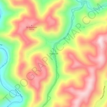
Name: Chapman topographic map, elevation, terrain.
Location: Chapman, Webster County, West Virginia, 26217, United States (38.52511 -80.48064 38.56511 -80.44064)
Average elevation: 578 m
Minimum elevation: 333 m
Maximum elevation: 784 m
Other topographic maps
Click on a map to view its topography, its elevation and its terrain.
Cowen
United States > West Virginia > Webster County
Cowen, Webster County, West Virginia, 26206, United States
Average elevation: 709 m
Addison (Webster Springs)
United States > West Virginia > Webster County
Addison (Webster Springs), Webster County, West Virginia, 26288, United States
Average elevation: 600 m
Wheeler
United States > West Virginia > Webster County
Wheeler, Webster County, West Virginia, 26215, United States
Average elevation: 547 m