
Jusan topographic map
Interactive map
Click on the map to display elevation.
About this map
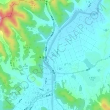
Name: Jusan topographic map, elevation, terrain.
Location: Jusan, Gokseong-gun, South Jeolla, 57502, South Korea (35.26919 127.12608 35.30919 127.16608)
Average elevation: 121 m
Minimum elevation: 72 m
Maximum elevation: 326 m
Other topographic maps
Click on a map to view its topography, its elevation and its terrain.
Oji-ri
South Korea > Gokseong-gun > Ogok-myeon > Oji-ri
Oji-ri, Ogok-myeon, Gokseong-gun, South Jeolla, 57544, South Korea
Average elevation: 109 m