
Aberdeen topographic map
Interactive map
Click on the map to display elevation.
About this map
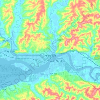
Name: Aberdeen topographic map, elevation, terrain.
Average elevation: 48 m
Minimum elevation: -5 m
Maximum elevation: 181 m
Other topographic maps
Click on a map to view its topography, its elevation and its terrain.
Westport
États-Unis d'Amérique > Washington > Grays Harbor County > Westport
Westport, Grays Harbor County, Washington, 98595, États-Unis d'Amérique
Average elevation: 2 m
Hoquiam
États-Unis d'Amérique > Washington > Grays Harbor County
Hoquiam, Grays Harbor County, Washington, 98550, États-Unis d'Amérique
Average elevation: 29 m