
Traunreut topographic map
Interactive map
Click on the map to display elevation.
About this map
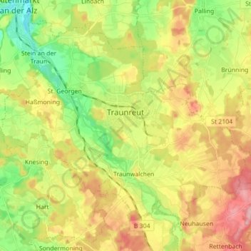
Name: Traunreut topographic map, elevation, terrain.
Location: Traunreut, Landkreis Traunstein, Bavaria, Germany (47.91887 12.52559 47.99690 12.66449)
Average elevation: 557 m
Minimum elevation: 489 m
Maximum elevation: 638 m
Other topographic maps
Click on a map to view its topography, its elevation and its terrain.
Burgham
Germany > Bavaria > Landkreis Traunstein > Seeon-Seebruck
Burgham, Seeon-Seebruck, Landkreis Traunstein, Bavaria, 83358, Germany
Average elevation: 525 m
Schönberg
Germany > Bavaria > Landkreis Traunstein > Kienberg
Schönberg, Kienberg, Obing (VGem), Landkreis Traunstein, Bavaria, 83361, Germany
Average elevation: 538 m
Pittenhart
Germany > Bavaria > Landkreis Traunstein
Pittenhart, Obing (VGem), Landkreis Traunstein, Bavaria, 83132, Germany
Average elevation: 567 m
Kienberg
Germany > Bavaria > Landkreis Traunstein
Kienberg, Obing (VGem), Landkreis Traunstein, Bavaria, 83361, Germany
Average elevation: 549 m
Gilling
Germany > Bavaria > Landkreis Traunstein > Petting
Gilling, Petting, Landkreis Traunstein, Bavaria, 83367, Germany
Average elevation: 477 m
Ruhpolding
Germany > Bavaria > Landkreis Traunstein
Ruhpolding, Landkreis Traunstein, Bavaria, 83324, Germany
Average elevation: 988 m
Schleching
Germany > Bavaria > Landkreis Traunstein
Schleching, Landkreis Traunstein, Bavaria, 83259, Germany
Average elevation: 958 m
Inzell
Germany > Bavaria > Landkreis Traunstein
Inzell, Landkreis Traunstein, Bavaria, 83334, Germany
Average elevation: 929 m
Tittmoning
Germany > Bavaria > Landkreis Traunstein
Tittmoning, Landkreis Traunstein, Bavaria, 84529, Germany
Average elevation: 453 m
St. Georgen
Germany > Bavaria > Landkreis Traunstein > Traunreut > St. Georgen
St. Georgen, Traunreut, Landkreis Traunstein, Bavaria, 83368, Germany
Average elevation: 541 m
Traunstein
Germany > Bavaria > Landkreis Traunstein
Traunstein, Landkreis Traunstein, Bavaria, 83278, Germany
Average elevation: 601 m
Trostberg
Germany > Bavaria > Landkreis Traunstein
Trostberg, Landkreis Traunstein, Bavaria, 83308, Germany
Average elevation: 528 m