
Thank you for supporting this site ❤️
Make a donation
Make a donation
Earlston topographic map
Click on the map to display elevation.
Thank you for supporting this site ❤️
Make a donation
Make a donation
About this map
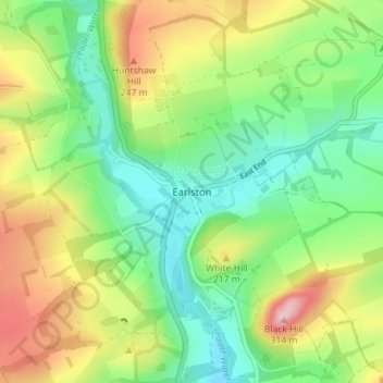
Name: Earlston topographic map, elevation, terrain.
Location: Earlston, Scottish Borders, Scotland, TD4 6BU, United Kingdom (55.61817 -2.69690 55.65817 -2.65690)
Average elevation: 169 m
Minimum elevation: 90 m
Maximum elevation: 300 m
Thank you for supporting this site ❤️
Make a donation
Make a donation
Other topographic maps
Click on a map to view its topography, its elevation and its terrain.
Hirsel Lake
United Kingdom > Scotland > Scottish Borders > Coldstream > The Hirsel
Average elevation: 37 m
Thank you for supporting this site ❤️
Make a donation
Make a donation
Thank you for supporting this site ❤️
Make a donation
Make a donation
Greenknowe Tower
United Kingdom > Scotland > Scottish Borders > Gordon > Nether Huntlywood
Average elevation: 157 m
Thank you for supporting this site ❤️
Make a donation
Make a donation
Curling Pond
United Kingdom > Scotland > Scottish Borders > Earlston > Georgefield
Average elevation: 153 m