
Libramont-Chevigny topographic map
Interactive map
Click on the map to display elevation.
About this map
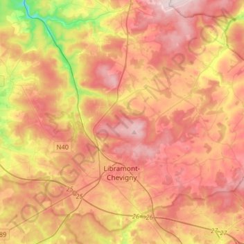
Name: Libramont-Chevigny topographic map, elevation, terrain.
Average elevation: 475 m
Minimum elevation: 332 m
Maximum elevation: 589 m
Other topographic maps
Click on a map to view its topography, its elevation and its terrain.
Bouillon
België > Luxemburg > Neufchâteau
Bouillon, Neufchâteau, Luxemburg, Wallonië, België
Average elevation: 342 m
Saint-Hubert
België > Luxemburg > Neufchâteau
Saint-Hubert, Neufchâteau, Luxemburg, Wallonië, 6870, België
Average elevation: 451 m
Semois
België > Luxemburg > Neufchâteau > Herbeumont
Semois, Herbeumont, Neufchâteau, Luxemburg, Wallonië, 6887, België
Average elevation: 312 m
Léglise
België > Luxemburg > Neufchâteau
Léglise, Neufchâteau, Luxemburg, Wallonië, 6860, België
Average elevation: 441 m
Xaimont
België > Luxemburg > Neufchâteau > Léglise
Xaimont, Léglise, Neufchâteau, Luxemburg, Wallonië, 6860, België
Average elevation: 430 m
Lahérie
België > Luxemburg > Neufchâteau
Lahérie, Longlier, Neufchâteau, Luxemburg, Wallonië, België
Average elevation: 457 m
Les Huzes
België > Luxemburg > Neufchâteau > Respelt
Les Huzes, Respelt, Longlier, Neufchâteau, Luxemburg, Wallonië, 6840, België
Average elevation: 465 m
Moircy
België > Luxemburg > Neufchâteau
Moircy, Libramont-Chevigny, Neufchâteau, Luxemburg, Wallonië, België
Average elevation: 474 m
Flohimont
België > Luxemburg > Neufchâteau
Flohimont, Saint-Pierre, Libramont-Chevigny, Neufchâteau, Luxemburg, Wallonië, 6800, België
Average elevation: 487 m
Séviscourt
België > Luxemburg > Neufchâteau
Séviscourt, Bras, Libramont-Chevigny, Neufchâteau, Luxemburg, Wallonië, 6800, België
Average elevation: 488 m
Assenois
België > Luxemburg > Neufchâteau
Assenois, Léglise, Neufchâteau, Luxemburg, Wallonië, België
Average elevation: 417 m
Biourge
België > Luxemburg > Neufchâteau
Biourge, Bertrix, Neufchâteau, Luxemburg, Wallonië, 6887, België
Average elevation: 407 m
Vesqueville
België > Luxemburg > Neufchâteau
Vesqueville, Saint-Hubert, Neufchâteau, Luxemburg, Wallonië, België
Average elevation: 495 m
Hamipré
België > Luxemburg > Neufchâteau > Hamipre
Hamipré, Hamipre, Neufchâteau, Luxemburg, Wallonië, 6840, België
Average elevation: 446 m
Longlier
België > Luxemburg > Neufchâteau
Longlier, Neufchâteau, Luxemburg, Wallonië, België
Average elevation: 467 m
Straimont
België > Luxemburg > Neufchâteau
Straimont, Herbeumont, Neufchâteau, Luxemburg, Wallonië, België
Average elevation: 397 m
Ochamps
België > Luxemburg > Neufchâteau
Ochamps, Libin, Neufchâteau, Luxemburg, Wallonië, België
Average elevation: 445 m
Grapfontaine
België > Luxemburg > Neufchâteau
Grapfontaine, Neufchâteau, Luxemburg, Wallonië, België
Average elevation: 407 m
Freux-Suzerain
België > Luxemburg > Neufchâteau > Freux
Freux-Suzerain, Freux, Libramont-Chevigny, Neufchâteau, Luxemburg, Wallonië, 6800, België
Average elevation: 474 m
Rondu
België > Luxemburg > Neufchâteau
Rondu, Remagne, Libramont-Chevigny, Neufchâteau, Luxemburg, Wallonië, België
Average elevation: 486 m
Mirwart
België > Luxemburg > Neufchâteau
Mirwart, Saint-Hubert, Neufchâteau, Luxemburg, Wallonië, België
Average elevation: 359 m
Gembes
België > Luxemburg > Neufchâteau > Daverdisse
Gembes, Daverdisse, Neufchâteau, Luxemburg, Wallonië, België
Average elevation: 366 m
Herbeumont
België > Luxemburg > Neufchâteau
Herbeumont, Neufchâteau, Luxemburg, Wallonië, 6887, België
Average elevation: 373 m
Awenne
België > Luxemburg > Neufchâteau > Saint-Hubert
Awenne, Saint-Hubert, Neufchâteau, Luxemburg, Wallonië, België
Average elevation: 375 m
Nimbermont
België > Luxemburg > Neufchâteau > Rondu
Nimbermont, Rondu, Remagne, Libramont-Chevigny, Neufchâteau, Luxemburg, Wallonië, België
Average elevation: 482 m
Tellin
België > Luxemburg > Neufchâteau
Tellin, Neufchâteau, Luxemburg, Wallonië, 6927, België
Average elevation: 310 m
Bras
België > Luxemburg > Neufchâteau
Bras, Libramont-Chevigny, Neufchâteau, Luxemburg, Wallonië, België
Average elevation: 485 m
Neufchâteau
België > Luxemburg > Neufchâteau
Neufchâteau, Luxemburg, Wallonië, 6840, België
Average elevation: 437 m
Paliseul
België > Luxemburg > Neufchâteau
Paliseul, Neufchâteau, Luxemburg, Wallonië, België
Average elevation: 393 m
Recogne
België > Luxemburg > Neufchâteau
Recogne, Libramont-Chevigny, Neufchâteau, Luxemburg, Wallonië, België
Average elevation: 480 m
Chemin des Huttes
België > Luxemburg > Neufchâteau > Hatrival
Chemin des Huttes, Hatrival, Saint-Hubert, Neufchâteau, Luxemburg, Wallonië, 6870, België
Average elevation: 472 m
Ourt
België > Luxemburg > Neufchâteau > Saint-Marie-Chevigny
Ourt, Saint-Marie-Chevigny, Libramont-Chevigny, Neufchâteau, Luxemburg, Wallonië, 6800, België
Average elevation: 509 m
Jehonville
België > Luxemburg > Neufchâteau > Bertrix
Jehonville, Bertrix, Neufchâteau, Luxemburg, Wallonië, België
Average elevation: 424 m
Anloy
België > Luxemburg > Neufchâteau
Anloy, Libin, Neufchâteau, Luxemburg, Wallonië, België
Average elevation: 408 m
Smuid
België > Luxemburg > Neufchâteau
Smuid, Libin, Neufchâteau, Luxemburg, Wallonië, België
Average elevation: 384 m
Bertrix
België > Luxemburg > Neufchâteau > Bertrix
Bertrix, Neufchâteau, Luxemburg, Wallonië, 6880, België
Average elevation: 408 m
Wellin
België > Luxemburg > Neufchâteau
Wellin, Neufchâteau, Luxemburg, Wallonië, België
Average elevation: 283 m
Arville
België > Luxemburg > Neufchâteau
Arville, Saint-Hubert, Neufchâteau, Luxemburg, Wallonië, België
Average elevation: 416 m
Nolinfaing
België > Luxemburg > Neufchâteau
Nolinfaing, Grapfontaine, Neufchâteau, Luxemburg, Wallonië, 6840, België
Average elevation: 431 m
Daverdisse
België > Luxemburg > Neufchâteau
Daverdisse, Neufchâteau, Luxemburg, Wallonië, 6929, België
Average elevation: 362 m
Haut-Fays
België > Luxemburg > Neufchâteau
Haut-Fays, Daverdisse, Neufchâteau, Luxemburg, Wallonië, 6929, België
Average elevation: 387 m
Bure
België > Luxemburg > Neufchâteau > Tellin
Bure, Tellin, Neufchâteau, Luxemburg, Wallonië, België
Average elevation: 310 m
Corbion
België > Luxemburg > Neufchâteau > Bouillon
Corbion, Bouillon, Neufchâteau, Luxemburg, Wallonië, 6838, België
Average elevation: 344 m
Cugnon
België > Luxemburg > Neufchâteau > Bertrix
Cugnon, Bertrix, Neufchâteau, Luxemburg, Wallonië, België
Average elevation: 331 m
Bonance
België > Luxemburg > Neufchâteau > Libramont > Libramont-Chevigny > Bonance
Bonance, Libramont-Chevigny, Libramont, Libramont-Chevigny, Neufchâteau, Luxemburg, Wallonië, 6800, België
Average elevation: 499 m
Halma
België > Luxemburg > Neufchâteau > Halma
Halma, Wellin, Neufchâteau, Luxemburg, Wallonië, 6922, België
Average elevation: 297 m
Noirefontaine
België > Luxemburg > Neufchâteau > Bouillon > Noirefontaine
Noirefontaine, Bouillon, Neufchâteau, Luxemburg, Wallonië, 6831, België
Average elevation: 331 m
Auby-sur-Semois
België > Luxemburg > Neufchâteau
Auby-sur-Semois, Bertrix, Neufchâteau, Luxemburg, Wallonië, België
Average elevation: 347 m
Dohan
België > Luxemburg > Neufchâteau > Bouillon
Dohan, Bouillon, Neufchâteau, Luxemburg, Wallonië, België
Average elevation: 284 m