
Blackford County topographic map
Interactive map
Click on the map to display elevation.
About this map
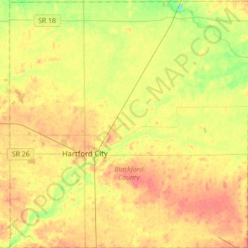
Name: Blackford County topographic map, elevation, terrain.
Location: Blackford County, Indiana, USA (40.37886 -85.44538 40.56792 -85.20086)
Average elevation: 274 m
Minimum elevation: 246 m
Maximum elevation: 296 m
Other topographic maps
Click on a map to view its topography, its elevation and its terrain.
Middle Fork of Wildcat Creek
Middle Fork of Wildcat Creek, Clinton County, Indiana, 46065, USA
Average elevation: 215 m
Mount Etna
USA > Indiana > Mount Etna
Mount Etna, Huntington County, Indiana, USA
Average elevation: 245 m
Bloomington
USA > Indiana > Bloomington
Bloomington, Monroe County, Indiana, USA
Average elevation: 241 m