
Thank you for supporting this site ❤️
Make a donation
Make a donation
Nunavut topographic map
Click on the map to display elevation.
Thank you for supporting this site ❤️
Make a donation
Make a donation
About this map
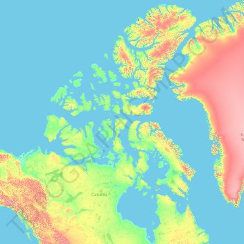
Name: Nunavut topographic map, elevation, terrain.
Location: Nunavut, Canada (51.16073 -120.68281 83.33621 -59.61368)
Average elevation: 387 m
Minimum elevation: -2 m
Maximum elevation: 4,429 m
Thank you for supporting this site ❤️
Make a donation
Make a donation
Other topographic maps
Click on a map to view its topography, its elevation and its terrain.
Toledo
Canada > Ontario > Leeds and Grenville Counties > Elizabethtown-Kitley
Average elevation: 121 m
Thank you for supporting this site ❤️
Make a donation
Make a donation