
Knon topographic map
Interactive map
Click on the map to display elevation.
About this map
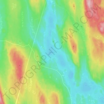
Name: Knon topographic map, elevation, terrain.
Location: Knon, Hagfors kommun, Provinz Värmland, Schweden (60.15839 13.64688 60.24205 13.71250)
Average elevation: 281 m
Minimum elevation: 212 m
Maximum elevation: 431 m
Other topographic maps
Click on a map to view its topography, its elevation and its terrain.
Gemeinde Årjäng
Gemeinde Årjäng, Provinz Värmland, Schweden
Average elevation: 168 m
Hagfors kommun
Hagfors kommun, Provinz Värmland, Schweden
Average elevation: 257 m
Sunne kommun
Sunne kommun, Provinz Värmland, Schweden
Average elevation: 194 m