
Thank you for supporting this site ❤️
Make a donation
Make a donation
Entreverges topographic map
Click on the map to display elevation.
Thank you for supporting this site ❤️
Make a donation
Make a donation
About this map
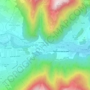
Name: Entreverges topographic map, elevation, terrain.
Average elevation: 830 m
Minimum elevation: 549 m
Maximum elevation: 1,459 m
Thank you for supporting this site ❤️
Make a donation
Make a donation
Other topographic maps
Click on a map to view its topography, its elevation and its terrain.
Lac du Môle
France > Auvergne-Rhône-Alpes > Haute-Savoie > La Tour > Chez les Maures
Average elevation: 711 m