
Stockton topographic map
Interactive map
Click on the map to display elevation.
About this map
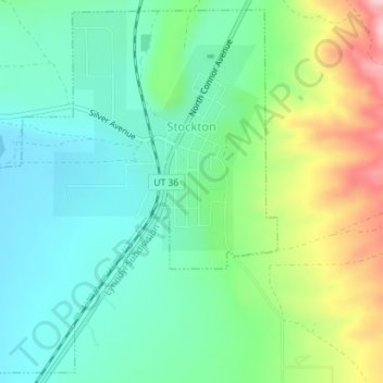
Name: Stockton topographic map, elevation, terrain.
Location: Stockton, Tooele County, Utah, 84071, United States (40.43577 -112.38278 40.46142 -112.35307)
Average elevation: 1,580 m
Minimum elevation: 1,512 m
Maximum elevation: 1,732 m
Other topographic maps
Click on a map to view its topography, its elevation and its terrain.
Dugway
United States > Utah > Tooele County
Dugway, Tooele County, Utah, 84022, United States
Average elevation: 1,496 m
Erda
United States > Utah > Tooele County
Erda, Tooele County, Utah, 84074, United States
Average elevation: 1,603 m
Stansbury Park
United States > Utah > Tooele County > Stansbury Park
Stansbury Park, Tooele County, Utah, United States
Average elevation: 1,317 m
Ibapah
United States > Utah > Tooele County
Ibapah, Tooele County, Utah, United States
Average elevation: 1,623 m
Tooele
United States > Utah > Tooele County
Tooele, Tooele County, Utah, United States
Average elevation: 1,610 m
Ophir
United States > Utah > Tooele County
Ophir, Tooele County, Utah, United States
Average elevation: 2,232 m
Wendover
United States > Utah > Tooele County
Wendover, Tooele County, Utah, United States
Average elevation: 1,325 m