
Thank you for supporting this site ❤️
Make a donation
Make a donation
Louan topographic map
Click on the map to display elevation.
Thank you for supporting this site ❤️
Make a donation
Make a donation
About this map
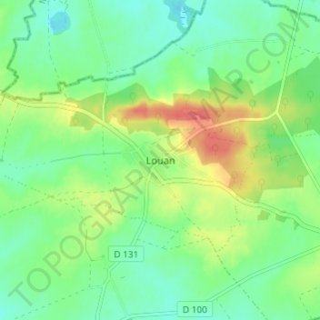
Name: Louan topographic map, elevation, terrain.
Average elevation: 169 m
Minimum elevation: 149 m
Maximum elevation: 203 m
Thank you for supporting this site ❤️
Make a donation
Make a donation
Other topographic maps
Click on a map to view its topography, its elevation and its terrain.
Fontaine-sous-Montaiguillon
France > Île-de-France > Seine-et-Marne > Louan-Villegruis-Fontaine
Average elevation: 171 m