
Thank you for supporting this site ❤️
Make a donation
Make a donation
Heiligenhaus topographic map
Click on the map to display elevation.
Thank you for supporting this site ❤️
Make a donation
Make a donation
About this map
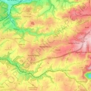
Name: Heiligenhaus topographic map, elevation, terrain.
Average elevation: 150 m
Minimum elevation: 19 m
Maximum elevation: 251 m
Thank you for supporting this site ❤️
Make a donation
Make a donation
Other topographic maps
Click on a map to view its topography, its elevation and its terrain.
Abtsküche / Haus Hetterscheidt
Germany > North Rhine-Westphalia > Kreis Mettmann > Heiligenhaus > Tüschen
Average elevation: 168 m