
Thank you for supporting this site ❤️
Make a donation
Make a donation
Ban Nongpie topographic map
Click on the map to display elevation.
Thank you for supporting this site ❤️
Make a donation
Make a donation
About this map
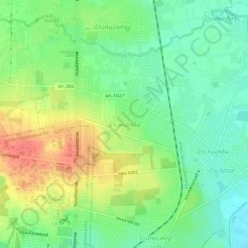
Name: Ban Nongpie topographic map, elevation, terrain.
Average elevation: 175 m
Minimum elevation: 151 m
Maximum elevation: 210 m
Thank you for supporting this site ❤️
Make a donation
Make a donation
Other topographic maps
Click on a map to view its topography, its elevation and its terrain.
Khon Kaen City Municipality
Khon Kaen is on the Khorat Plateau, elevation 187 m, and is the center of the mid-northeastern provincial group of Thailand, according to the Thai government. Its coordinates are 16°26′N 102°50′E / 16.433°N 102.833°E / 16.433; 102.833. The city municipality has a population of 114,459, while…
Average elevation: 163 m