
Bergamo topographic map
Interactive map
Click on the map to display elevation.
About this map
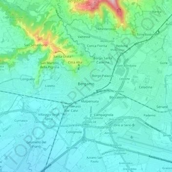
Name: Bergamo topographic map, elevation, terrain.
Location: Bergamo, Lombardei, Italien (45.65542 9.61936 45.73140 9.71371)
Average elevation: 269 m
Minimum elevation: 206 m
Maximum elevation: 615 m
Die Oberstadt, Città Alta (ital. città = Stadt, alta = hoch), die heute ganz unter Denkmalschutz steht, zieht sich wie ein Amphitheater an einer Anhöhe empor und ist vollständig mit einer fünf Kilometer langen Stadtmauer umgeben. Die heutigen Mauern stammen aus dem 16. Jahrhundert und beinhalten mehrere Bastionen. Das Zentrum der historischen Oberstadt ist die Piazza Vecchia, an der das mittelalterliche Rathaus Palazzo della Ragione mit dem Stadtturm Torre Civica steht.
Other topographic maps
Click on a map to view its topography, its elevation and its terrain.
Orio al Serio
Orio al Serio, Bergamo, Lombardei, Italien
Average elevation: 238 m