
Chaville topographic map
Interactive map
Click on the map to display elevation.
About this map
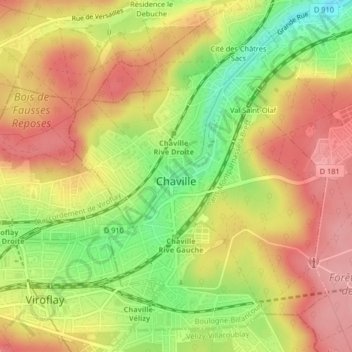
Name: Chaville topographic map, elevation, terrain.
Average elevation: 127 m
Minimum elevation: 57 m
Maximum elevation: 179 m
Other topographic maps
Click on a map to view its topography, its elevation and its terrain.
Quartier Boieldieu
France > Ile-de-France > Hauts-de-Seine > Puteaux
Quartier Boieldieu, Puteaux, Arrondissement of Nanterre, Hauts-de-Seine, Ile-de-France, Metropolitan France, 92800, France
Average elevation: 52 m
Châtillon
France > Ile-de-France > Hauts-de-Seine
Châtillon, Antony, Hauts-de-Seine, Ile-de-France, Metropolitan France, 92320, France
Average elevation: 102 m
Bagneux
France > Ile-de-France > Hauts-de-Seine
Bagneux, Antony, Hauts-de-Seine, Ile-de-France, Metropolitan France, 92220, France
Average elevation: 91 m
Colombes
France > Ile-de-France > Hauts-de-Seine
Colombes, Arrondissement of Nanterre, Hauts-de-Seine, Ile-de-France, Metropolitan France, 92700, France
Average elevation: 37 m
Hameau de Bois Preau
France > Ile-de-France > Hauts-de-Seine > Rueil-Malmaison
Hameau de Bois Preau, Village Richelieu-Châtaigneraie, Rueil-Malmaison, Arrondissement of Nanterre, Hauts-de-Seine, Ile-de-France, Metropolitan France, 92500, France
Average elevation: 90 m
Cité des Châtres Sacs
France > Ile-de-France > Hauts-de-Seine > Chaville
Cité des Châtres Sacs, Chaville, Boulogne-Billancourt, Hauts-de-Seine, Ile-de-France, Metropolitan France, 92370, France
Average elevation: 124 m
Sèvres
France > Ile-de-France > Hauts-de-Seine
Sèvres, Boulogne-Billancourt, Hauts-de-Seine, Ile-de-France, Metropolitan France, 92310, France
Average elevation: 102 m
La Garenne-Colombes
France > Ile-de-France > Hauts-de-Seine
La Garenne-Colombes, Arrondissement of Nanterre, Hauts-de-Seine, Ile-de-France, Metropolitan France, 92250, France
Average elevation: 45 m
Résidence Beausoleil
France > Ile-de-France > Hauts-de-Seine > Saint-Cloud
Résidence Beausoleil, Saint-Cloud, Arrondissement of Nanterre, Hauts-de-Seine, Ile-de-France, Metropolitan France, 92210, France
Average elevation: 78 m
Jardin de la Mairie
France > Ile-de-France > Hauts-de-Seine > Boulogne-Billancourt
Jardin de la Mairie, Centre Ville, Boulogne-Billancourt, Hauts-de-Seine, Ile-de-France, Metropolitan France, 92100, France
Average elevation: 52 m
Terrasse de l'observatoire
France > Ile-de-France > Hauts-de-Seine > Meudon
Terrasse de l'observatoire, Allée du Canada, Le Clos Madame, Fleury, Meudon, Boulogne-Billancourt, Hauts-de-Seine, Ile-de-France, Metropolitan France, 92190, France
Average elevation: 129 m
Rueil-Malmaison
France > Ile-de-France > Hauts-de-Seine
Rueil-Malmaison, Arrondissement of Nanterre, Hauts-de-Seine, Ile-de-France, Metropolitan France, 92500, France
Average elevation: 78 m
Neuilly-sur-Seine
France > Ile-de-France > Hauts-de-Seine
Neuilly-sur-Seine, Arrondissement of Nanterre, Hauts-de-Seine, Ile-de-France, Metropolitan France, 92200, France
Average elevation: 41 m
Courbevoie
France > Ile-de-France > Hauts-de-Seine
Courbevoie, Arrondissement of Nanterre, Hauts-de-Seine, Ile-de-France, Metropolitan France, 92400, France
Average elevation: 44 m
Clichy
France > Ile-de-France > Hauts-de-Seine
Clichy, Arrondissement of Nanterre, Hauts-de-Seine, Ile-de-France, Metropolitan France, 92110, France
Average elevation: 36 m
Clamart
France > Ile-de-France > Hauts-de-Seine > Clamart > Clamart
Clamart, Antony, Hauts-de-Seine, Ile-de-France, Metropolitan France, 92140, France
Average elevation: 104 m
Malakoff
France > Ile-de-France > Hauts-de-Seine > Malakoff > Malakoff
Malakoff, Antony, Hauts-de-Seine, Ile-de-France, Metropolitan France, 92240, France
Average elevation: 73 m
Boulogne-Billancourt
France > Ile-de-France > Hauts-de-Seine
Boulogne-Billancourt, Hauts-de-Seine, Ile-de-France, Metropolitan France, 92100, France
Average elevation: 43 m
Levallois-Perret
France > Ile-de-France > Hauts-de-Seine
Levallois-Perret, Arrondissement of Nanterre, Hauts-de-Seine, Ile-de-France, Metropolitan France, 92300, France
Average elevation: 40 m
Asnières-sur-Seine
France > Ile-de-France > Hauts-de-Seine
Asnières-sur-Seine, Arrondissement of Nanterre, Hauts-de-Seine, Ile-de-France, Metropolitan France, 92600, France
Average elevation: 35 m
Bourg-la-Reine
France > Ile-de-France > Hauts-de-Seine
Bourg-la-Reine, Antony, Hauts-de-Seine, Ile-de-France, Metropolitan France, 92340, France
Average elevation: 70 m
Nanterre
France > Ile-de-France > Hauts-de-Seine
Nanterre, Arrondissement of Nanterre, Hauts-de-Seine, Ile-de-France, Metropolitan France, 92000, France
Average elevation: 45 m
Bois-Colombes
France > Ile-de-France > Hauts-de-Seine
Bois-Colombes, Arrondissement of Nanterre, Hauts-de-Seine, Ile-de-France, Metropolitan France, 92270, France
Average elevation: 39 m
Garches
France > Ile-de-France > Hauts-de-Seine
Garches, Arrondissement of Nanterre, Hauts-de-Seine, Ile-de-France, Metropolitan France, 92380, France
Average elevation: 131 m
Saint-Cloud
France > Ile-de-France > Hauts-de-Seine
Saint-Cloud, Arrondissement of Nanterre, Hauts-de-Seine, Ile-de-France, Metropolitan France, 92210, France
Average elevation: 71 m