
James Peak topographic map
Interactive map
Click on the map to display elevation.
About this map
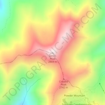
Name: James Peak topographic map, elevation, terrain.
Location: James Peak, Cache County, Utah, United States (41.39137 -111.79297 41.39147 -111.79287)
Average elevation: 2,550 m
Minimum elevation: 2,207 m
Maximum elevation: 2,859 m
Other topographic maps
Click on a map to view its topography, its elevation and its terrain.
Logan
United States > Utah > Cache County
Logan, Cache County, Utah, United States
Average elevation: 1,498 m
Trenton
United States > Utah > Cache County
Trenton, Cache County, Utah, 84338, United States
Average elevation: 1,392 m
Hyrum
United States > Utah > Cache County
Hyrum, Cache County, Utah, 84319, United States
Average elevation: 1,439 m
Lewiston
United States > Utah > Cache County
Lewiston, Cache County, Utah, 84320, United States
Average elevation: 1,376 m
Benson
United States > Utah > Cache County
Benson, Cache County, Utah, United States
Average elevation: 1,442 m
Peter
United States > Utah > Cache County > Petersboro
Peter, Petersboro, Cache County, Utah, United States
Average elevation: 1,445 m
Clarkston
United States > Utah > Cache County
Clarkston, Cache County, Utah, 84305, United States
Average elevation: 1,498 m
River Heights
United States > Utah > Cache County
River Heights, Cache County, Utah, United States
Average elevation: 1,395 m
Mendon
United States > Utah > Cache County
Mendon, Cache County, Utah, United States
Average elevation: 1,399 m
Smithfield
United States > Utah > Cache County
Smithfield, Cache County, Utah, 84335, United States
Average elevation: 1,404 m
Logan Canyon
United States > Utah > Cache County
Logan Canyon, Cache County, Utah, 84322, United States
Average elevation: 1,780 m
Mount Pisgah
United States > Utah > Cache County
Mount Pisgah, Cache County, Utah, United States
Average elevation: 1,862 m
Nibley
United States > Utah > Cache County
Nibley, Cache County, Utah, United States
Average elevation: 1,428 m
Logan River
United States > Utah > Cache County
Logan River, Cache County, Utah, United States
Average elevation: 1,919 m
Providence Canyon
United States > Utah > Cache County
Providence Canyon, Cache County, Utah, 84332, United States
Average elevation: 1,829 m
Wellsville
United States > Utah > Cache County
Wellsville, Cache County, Utah, 84339, United States
Average elevation: 1,545 m
Logan
United States > Utah > Cache County > Logan > Logan
Logan, Cache County, Utah, 84321, United States
Average elevation: 1,419 m
Hyde Park
United States > Utah > Cache County
Hyde Park, Cache County, Utah, 84318, United States
Average elevation: 1,418 m
North Logan
United States > Utah > Cache County
North Logan, Cache County, Utah, 84341, United States
Average elevation: 1,487 m
Hyrum
United States > Utah > Cache County > Hyrum > Hyrum
Hyrum, Cache County, Utah, 84319-1660, United States
Average elevation: 1,439 m
Peter Sinks
United States > Utah > Cache County
Peter Sinks, Cache County, Utah, United States
Average elevation: 2,555 m
Providence
United States > Utah > Cache County
Providence, Cache County, Utah, 84332, United States
Average elevation: 1,434 m