
Cotthembos topographic map
Interactive map
Click on the map to display elevation.
About this map
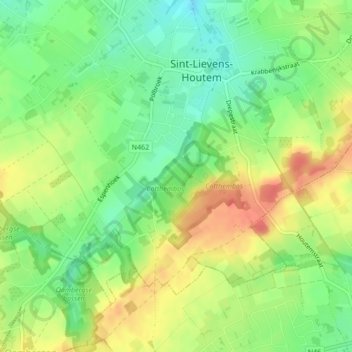
Name: Cotthembos topographic map, elevation, terrain.
Average elevation: 55 m
Minimum elevation: 30 m
Maximum elevation: 83 m
Other topographic maps
Click on a map to view its topography, its elevation and its terrain.
Zonnegem
België > Vlaanderen > Sint-Lievens-Houtem
Zonnegem, Sint-Lievens-Houtem, Aalst, Oost-Vlaanderen, Vlaanderen, België
Average elevation: 42 m
Bavegem
België > Vlaanderen > Sint-Lievens-Houtem > Bavegem
Bavegem, Sint-Lievens-Houtem, Oost-Vlaanderen, Vlaanderen, 9520, België
Average elevation: 31 m