
Ascension Island topographic map
Interactive map
Click on the map to display elevation.
About this map
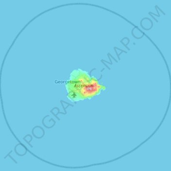
Name: Ascension Island topographic map, elevation, terrain.
Average elevation: 5 m
Minimum elevation: 0 m
Maximum elevation: 801 m
Other topographic maps
Click on a map to view its topography, its elevation and its terrain.
Tristan da Cunha
Saint Helena, Ascension and Tristan da Cunha
Tristan da Cunha, Saint Helena, Ascension and Tristan da Cunha
Average elevation: 0 m
Saint Helena
Saint Helena, Ascension and Tristan da Cunha > Saint Helena > Sandy Bay
Saint Helena, Sandy Bay, Saint Helena, STHL 1ZZ, Saint Helena, Ascension and Tristan da Cunha
Average elevation: 9 m