
Τήλος topographic map
Interactive map
Click on the map to display elevation.
About this map
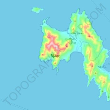
Name: Τήλος topographic map, elevation, terrain.
Average elevation: 43 m
Minimum elevation: 0 m
Maximum elevation: 636 m
Other topographic maps
Click on a map to view its topography, its elevation and its terrain.
Δημοτική Ενότητα Θήρας
Grécia > Αιγαίο > Δημοτική Ενότητα Θήρας
Δημοτική Ενότητα Θήρας, Δήμος Θήρας, Περιφερειακή Ενότητα Θήρας, Περιφέρεια Νοτίου Αιγαίου, Αιγαίο, Grécia
Average elevation: 12 m