
Les Capucins - Saint-Germain topographic map
Interactive map
Click on the map to display elevation.
About this map
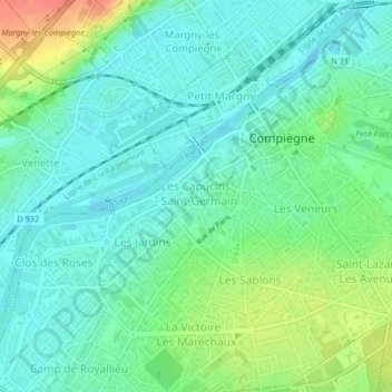
Name: Les Capucins - Saint-Germain topographic map, elevation, terrain.
Average elevation: 45 m
Minimum elevation: 29 m
Maximum elevation: 80 m
Other topographic maps
Click on a map to view its topography, its elevation and its terrain.
Saint-Lazare - Les Avenues
França > Norte-Passo-de-Calais e Picardia > Compiègne
Saint-Lazare - Les Avenues, Compiègne, Oise, Norte-Passo-de-Calais e Picardia, França metropolitana, 60200, França
Average elevation: 52 m