
Keyport topographic map
Interactive map
Click on the map to display elevation.
About this map
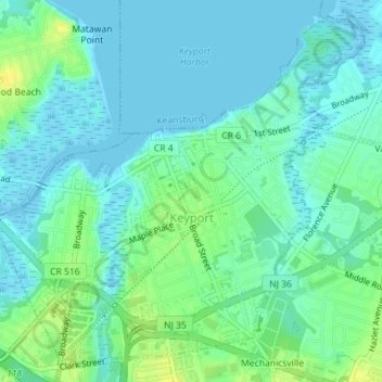
Name: Keyport topographic map, elevation, terrain.
Location: Keyport, Monmouth County, New Jersey, 07735, United States (40.42261 -74.21806 40.44738 -74.18353)
Average elevation: 6 m
Minimum elevation: -3 m
Maximum elevation: 19 m
Other topographic maps
Click on a map to view its topography, its elevation and its terrain.
Tinton Falls
United States > New Jersey > Monmouth County
Tinton Falls, Monmouth County, New Jersey, United States
Average elevation: 23 m
Atlantic Highlands
United States > New Jersey > Monmouth County
Atlantic Highlands, Monmouth County, New Jersey, 07716, United States
Average elevation: 9 m
Hazlet Township
United States > New Jersey > Monmouth County
Hazlet Township, Monmouth County, New Jersey, 07730, United States
Average elevation: 15 m
Aberdeen Township
United States > New Jersey > Monmouth County
Aberdeen Township, Monmouth County, New Jersey, United States
Average elevation: 17 m
Matawan
United States > New Jersey > Monmouth County
Matawan, Monmouth County, New Jersey, United States
Average elevation: 20 m
Fletcher Lake
United States > New Jersey > Monmouth County > Bradley Beach
Fletcher Lake, Bradley Beach, Monmouth County, New Jersey, United States
Average elevation: 4 m
Candlewood
United States > New Jersey > Monmouth County > Howell Township > Candlewood
Candlewood, Howell Township, Monmouth County, New Jersey, 07731, United States
Average elevation: 33 m
Middletown Township
United States > New Jersey > Monmouth County
Middletown Township, Monmouth County, New Jersey, United States
Average elevation: 18 m
Ocean Township
United States > New Jersey > Monmouth County
Ocean Township, Monmouth County, New Jersey, 07755, United States
Average elevation: 21 m
Freehold Township
United States > New Jersey > Monmouth County
Freehold Township, Monmouth County, New Jersey, 07728, United States
Average elevation: 41 m