
Leioa topographic map
Interactive map
Click on the map to display elevation.
About this map
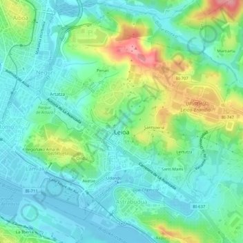
Name: Leioa topographic map, elevation, terrain.
Location: Leioa, Andraka, Biscaye, Pays basque autonome, 48620, Espagne (43.31379 -3.01108 43.34356 -2.96056)
Average elevation: 33 m
Minimum elevation: -3 m
Maximum elevation: 117 m
Other topographic maps
Click on a map to view its topography, its elevation and its terrain.
Bakio
Espagne > Pays basque autonome > Andraka
Bakio, Andraka, Biscaye, Pays basque autonome, 48620, Espagne
Average elevation: 138 m
Erandio
Espagne > Pays basque autonome > Andraka
Erandio, Andraka, Biscaye, Pays basque autonome, 48620, Espagne
Average elevation: 42 m