
Bloomington topographic map
Interactive map
Click on the map to display elevation.
About this map
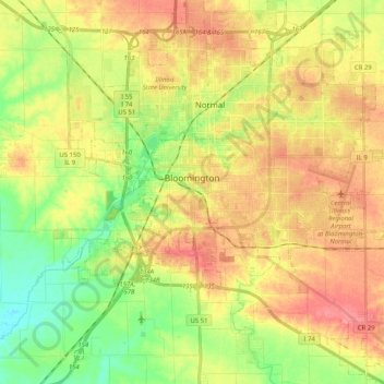
Name: Bloomington topographic map, elevation, terrain.
Location: Bloomington, McLean County, Illinois, United States (40.42944 -89.06772 40.51835 -88.86354)
Average elevation: 246 m
Minimum elevation: 210 m
Maximum elevation: 280 m
Bloomington is located at 40°29′03″N 88°59′37″W. The city is at an elevation of 797 feet (243 m) above sea level. According to the 2010 census, Bloomington has a total area of 27.229 square miles (70.52 km2), of which 27.22 square miles (70.50 km2) (or 99.97%) is land and 0.009 square miles (0.02 km2) (or 0.03%) is water.
Other topographic maps
Click on a map to view its topography, its elevation and its terrain.
Hudson
United States > Illinois > McLean County
Hudson, McLean County, Illinois, United States
Average elevation: 234 m
Towanda
United States > Illinois > McLean County
Towanda, McLean County, Illinois, 61776, United States
Average elevation: 239 m
Normal
United States > Illinois > McLean County
Normal, McLean County, Illinois, United States
Average elevation: 249 m
Anchor
United States > Illinois > McLean County
Anchor, McLean County, Illinois, United States
Average elevation: 235 m