
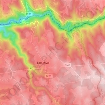
Lamativie topographic map
Interactive map
Click on the map to display elevation.
About this map
Name: Lamativie topographic map, elevation, terrain.
Average elevation: 534 m
Minimum elevation: 268 m
Maximum elevation: 644 m
Other topographic maps
Click on a map to view its topography, its elevation and its terrain.
Marraufin
France > Occitanie > Lot > Sousceyrac-en-Quercy
Marraufin, Lacam-d'Ourcet, Sousceyrac-en-Quercy, Figeac, Lot, Occitanie, France métropolitaine, 46190, France
Average elevation: 481 m
Calviac
France > Occitanie > Lot > Sousceyrac-en-Quercy
Calviac, Sousceyrac-en-Quercy, Figeac, Lot, Occitanie, France métropolitaine, 46190, France
Average elevation: 613 m
Sousceyrac
France > Occitanie > Lot > Sousceyrac-en-Quercy
Sousceyrac, Sousceyrac-en-Quercy, Figeac, Lot, Occitanie, France métropolitaine, 46190, France
Average elevation: 542 m