
Monbazillac topographic map
Interactive map
Click on the map to display elevation.
About this map
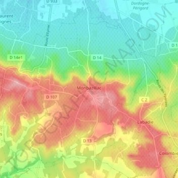
Name: Monbazillac topographic map, elevation, terrain.
Average elevation: 103 m
Minimum elevation: 41 m
Maximum elevation: 188 m
Other topographic maps
Click on a map to view its topography, its elevation and its terrain.
Carves
França > Nouvelle-Aquitaine > Dordogne
Carves, Sarlat-la-Canéda, Dordogne, Nouvelle-Aquitaine, França metropolitana, 24170, França
Average elevation: 188 m
Campagne
França > Nouvelle-Aquitaine > Dordogne
Campagne, Sarlat-la-Canéda, Dordogne, Nouvelle-Aquitaine, França metropolitana, 24260, França
Average elevation: 137 m