
Cummington topographic map
Interactive map
Click on the map to display elevation.
About this map
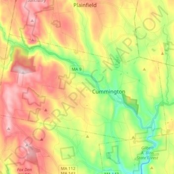
Name: Cummington topographic map, elevation, terrain.
Average elevation: 435 m
Minimum elevation: 252 m
Maximum elevation: 633 m
Other topographic maps
Click on a map to view its topography, its elevation and its terrain.
Northampton
États-Unis d'Amérique > Massachusetts > Hampshire County > Northampton
Northampton, Hampshire County, Massachusetts, États-Unis d'Amérique
Average elevation: 71 m
Amherst
États-Unis d'Amérique > Massachusetts > Hampshire County
Amherst, Hampshire County, Massachusetts, États-Unis d'Amérique
Average elevation: 120 m