
Las Tunitas topographic map
Interactive map
Click on the map to display elevation.
About this map
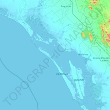
Name: Las Tunitas topographic map, elevation, terrain.
Location: Las Tunitas, Angostura, Sinaloa, México (24.76016 -108.55233 25.40016 -107.91233)
Average elevation: 16 m
Minimum elevation: -7 m
Maximum elevation: 653 m
Other topographic maps
Click on a map to view its topography, its elevation and its terrain.
La Reforma
México > Sinaloa > La Reforma
La Reforma, Angostura, Sinaloa, 81680, México
Average elevation: 5 m
Prados del Sur
Prados del Sur, Culiacán, Sinaloa, 80296, México
Average elevation: 72 m