
Maplewood topographic map
Interactive map
Click on the map to display elevation.
About this map
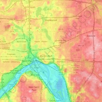
Name: Maplewood topographic map, elevation, terrain.
Location: Maplewood, Ramsey County, Minnesota, United States (44.89078 -93.10597 45.03688 -92.98423)
Average elevation: 279 m
Minimum elevation: 207 m
Maximum elevation: 335 m
Other topographic maps
Click on a map to view its topography, its elevation and its terrain.
Saint Paul
United States > Minnesota > Ramsey County
Saint Paul, Ramsey County, Minnesota, United States
Average elevation: 268 m
Battle Creek
United States > Minnesota > Ramsey County > Saint Paul
Battle Creek, Southeast, Saint Paul, Ramsey County, Minnesota, United States
Average elevation: 264 m
North St. Paul
United States > Minnesota > Ramsey County
North St. Paul, Ramsey County, Minnesota, United States
Average elevation: 302 m
Little Canada
United States > Minnesota > Ramsey County
Little Canada, Ramsey County, Minnesota, United States
Average elevation: 277 m
Beaver Lake
United States > Minnesota > Ramsey County > Maplewood
Beaver Lake, Maplewood, Ramsey County, Minnesota, United States
Average elevation: 304 m
Saint Paul
United States > Minnesota > Ramsey County > Saint Paul
Saint Paul, Ramsey County, Minnesota, 55101, United States
Average elevation: 273 m
North Oaks
United States > Minnesota > Ramsey County
North Oaks, Ramsey County, Minnesota, United States
Average elevation: 280 m
Roseville
United States > Minnesota > Ramsey County
Roseville, Ramsey County, Minnesota, 55113, United States
Average elevation: 284 m
White Bear Township
United States > Minnesota > Ramsey County
White Bear Township, Ramsey County, Minnesota, 55110, United States
Average elevation: 282 m
Southeast
United States > Minnesota > Ramsey County > Saint Paul
Southeast, Saint Paul, Ramsey County, Minnesota, United States
Average elevation: 263 m
White Bear Lake
United States > Minnesota > Ramsey County
White Bear Lake, Ramsey County, Minnesota, 55110, United States
Average elevation: 289 m
Highland Park
United States > Minnesota > Ramsey County > Saint Paul
Highland Park, Highland, Saint Paul, Ramsey County, Minnesota, United States
Average elevation: 255 m
Mounds View
United States > Minnesota > Ramsey County
Mounds View, Ramsey County, Minnesota, United States
Average elevation: 276 m
Summit Hill
United States > Minnesota > Ramsey County > Saint Paul
Summit Hill, Saint Paul, Ramsey County, Minnesota, United States
Average elevation: 267 m
New Brighton
United States > Minnesota > Ramsey County
New Brighton, Ramsey County, Minnesota, 55112, United States
Average elevation: 282 m
South Saint Anthony Park
United States > Minnesota > Ramsey County > Saint Paul
South Saint Anthony Park, Saint Anthony Park, Saint Paul, Ramsey County, Minnesota, United States
Average elevation: 270 m
Vadnais Heights
United States > Minnesota > Ramsey County
Vadnais Heights, Ramsey County, Minnesota, 55127, United States
Average elevation: 279 m
White Bear Township
United States > Minnesota > Ramsey County
White Bear Township, Ramsey County, Minnesota, United States
Average elevation: 283 m
Shoreview
United States > Minnesota > Ramsey County
Shoreview, Ramsey County, Minnesota, 55126, United States
Average elevation: 279 m