
Alcañiz topographic map
Interactive map
Click on the map to display elevation.
About this map
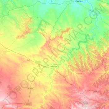
Name: Alcañiz topographic map, elevation, terrain.
Location: Alcañiz, Bajo Aragón, Teruel, Aragon, Spain (40.97551 -0.37625 41.19201 0.03692)
Average elevation: 364 m
Minimum elevation: 108 m
Maximum elevation: 696 m
Other topographic maps
Click on a map to view its topography, its elevation and its terrain.
Calanda
Spain > Aragon > Bajo Aragón > Calanda
Calanda, Bajo Aragón, Teruel, Aragon, 44570, Spain
Average elevation: 504 m