
Cómpeta topographic map
Interactive map
Click on the map to display elevation.
About this map
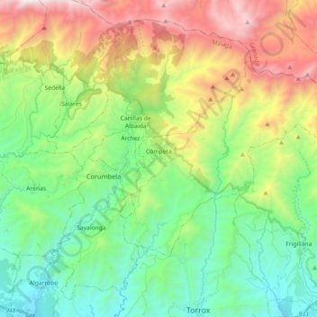
Name: Cómpeta topographic map, elevation, terrain.
Location: Cómpeta, La Axarquía, Malaga, Andalousie, 29754, Espagne (36.78514 -3.99471 36.87372 -3.81520)
Average elevation: 694 m
Minimum elevation: 27 m
Maximum elevation: 1,980 m
Cómpeta est située sur le versant méridional de la Sierra d'Almijara, à 650 m d'altitude et à environ 27 km de Nerja.