
Morea/Moreda topographic map
Interactive map
Click on the map to display elevation.
About this map
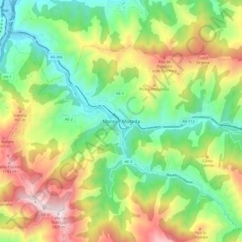
Name: Morea/Moreda topographic map, elevation, terrain.
Location: Morea/Moreda, Aller, Asturies, 33670, Espagne (43.12840 -5.77844 43.20840 -5.69844)
Average elevation: 652 m
Minimum elevation: 234 m
Maximum elevation: 1,300 m
Other topographic maps
Click on a map to view its topography, its elevation and its terrain.