
Tocha topographic map
Interactive map
Click on the map to display elevation.
About this map
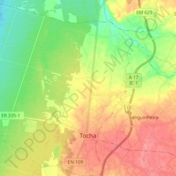
Name: Tocha topographic map, elevation, terrain.
Location: Tocha, Cantanhede, Coimbra, Portugal (40.29105 -8.84633 40.38894 -8.71961)
Average elevation: 43 m
Minimum elevation: 9 m
Maximum elevation: 79 m
Other topographic maps
Click on a map to view its topography, its elevation and its terrain.
Outil
Portugal > Coimbra > Cantanhede
Outil, Cantanhede, Coimbra, 3060-130, Portugal
Average elevation: 92 m
Vila Nova
Portugal > Coimbra > Cantanhede
Vila Nova, Portunhos e Outil, Cantanhede, Coimbra, 3025-341, Portugal
Average elevation: 97 m
Tarelhos
Portugal > Coimbra > Cantanhede
Tarelhos, Cantanhede e Pocariça, Cantanhede, Coimbra, 3060-179, Portugal
Average elevation: 56 m
Póvoa da Lomba
Portugal > Coimbra > Cantanhede
Póvoa da Lomba, Cantanhede e Pocariça, Cantanhede, Coimbra, 3060-130, Portugal
Average elevation: 85 m
Portunhos
Portugal > Coimbra > Cantanhede
Portunhos, Cantanhede, Coimbra, 3025-341, Portugal
Average elevation: 82 m
Pocariça
Portugal > Coimbra > Cantanhede
Pocariça, Cantanhede, Coimbra, 3060-909, Portugal
Average elevation: 70 m