
Make a donation
Inna topographic map
Click on the map to display elevation.
Make a donation
About this map
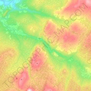
Name: Inna topographic map, elevation, terrain.
Location: Inna, Trøndelag, Norway (63.66161 11.72055 63.75660 12.02628)
Average elevation: 420 m
Minimum elevation: 18 m
Maximum elevation: 959 m
Make a donation
Other topographic maps
Click on a map to view its topography, its elevation and its terrain.
Trondheim
Norway > Trøndelag > Trondheim
Trondheim is situated where the River Nidelva meets Trondheim Fjord with an excellent harbour and sheltered condition. The river used to be deep enough for most boats in the Middle Ages. An avalanche of mud and stones made it less navigable and partly ruined the harbour in the mid-17th century. The…
Average elevation: 118 m
Make a donation
Make a donation
Make a donation
Make a donation
Make a donation
Make a donation
Make a donation
Make a donation
Botn
With a gradually descending bottom slope beneath the inlet, the basin lacks strong internal thresholds (abruptly steepening slopes) that often isolates the deep of fjord basins from imported tidal currents, thus leaving the Botn basin 'hydrodynamically open' (with very weak topographical stratifications).…
Average elevation: 48 m
Make a donation
Make a donation
Make a donation
Make a donation
Make a donation
Make a donation
Make a donation
Make a donation
Make a donation