
Make a donation
Valencia topographic map
Click on the map to display elevation.
Make a donation
Valencia
The maximum of precipitation occurs in autumn, coinciding with the time of the year when cold drop (gota fría) episodes of heavy rainfall—associated to cut-off low pressure systems at high altitude— are common along the Western mediterranean coast. The year-on-year variability in precipitation may be, however, considerable, as exemplified by large floods in 1957 and 2024, which both occurred in the month of October. Snowfall almost does not occur at all; the most recent occasion snow accumulated on the ground was on 11 January 1960.
Make a donation
About this map
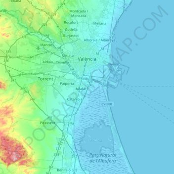
Name: Valencia topographic map, elevation, terrain.
Average elevation: 37 m
Minimum elevation: -6 m
Maximum elevation: 346 m
Make a donation
Other topographic maps
Click on a map to view its topography, its elevation and its terrain.
Platja del Cabanyal - Les Arenes
Spain > Valencian Community > Comarca de València > Valencia
Average elevation: 2 m