
Abingdon topographic map
Interactive map
Click on the map to display elevation.
About this map
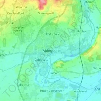
Name: Abingdon topographic map, elevation, terrain.
Average elevation: 64 m
Minimum elevation: 45 m
Maximum elevation: 136 m
Other topographic maps
Click on a map to view its topography, its elevation and its terrain.
North Hinksey
Royaume-Uni > Angleterre > Oxfordshire > Vale of White Horse
North Hinksey, Vale of White Horse, Oxfordshire, Angleterre, Royaume-Uni
Average elevation: 78 m