
Thank you for supporting this site ❤️
Make a donation
Make a donation
Baabdat topographic map
Click on the map to display elevation.
Thank you for supporting this site ❤️
Make a donation
Make a donation
Baabdat
Baabdat (Arabic: بعبدات) is a town located in the Matn District of Mount Lebanon, 22 km from Beirut at an altitude ranging between 600 and 1100 meters above sea level. The lush pine forests that surround the town make it a very popular summer resort for those escaping the busy coastal cities of Lebanon, especially the capital, Beirut. The town's proximity to Brummana, one of Mount Lebanon's most active summer destinations, makes Baabdat a major tourist destination in the summer.
Thank you for supporting this site ❤️
Make a donation
Make a donation
About this map
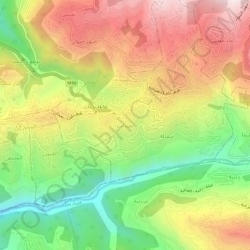
Name: Baabdat topographic map, elevation, terrain.
Average elevation: 740 m
Minimum elevation: 340 m
Maximum elevation: 1,155 m
Thank you for supporting this site ❤️
Make a donation
Make a donation
Other topographic maps
Click on a map to view its topography, its elevation and its terrain.