
Blandouet topographic map
Interactive map
Click on the map to display elevation.
About this map
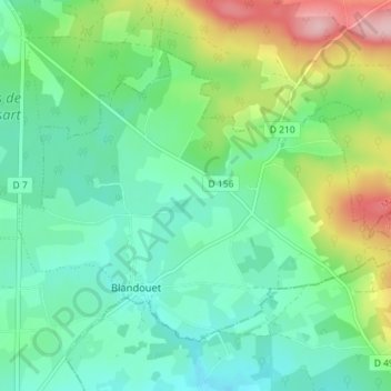
Name: Blandouet topographic map, elevation, terrain.
Average elevation: 132 m
Minimum elevation: 79 m
Maximum elevation: 261 m
« Blandouet », dans Alphonse-Victor Angot et Ferdinand Gaugain, Dictionnaire historique, topographique et biographique de la Mayenne, Laval, Goupil, 1900-1910 [détail des éditions] (lire en ligne)
Other topographic maps
Click on a map to view its topography, its elevation and its terrain.
Saint-Jean-sur-Erve
France > Pays de la Loire > Mayenne > Blandouet-Saint Jean
Saint-Jean-sur-Erve, Blandouet-Saint Jean, Mayenne, Pays de la Loire, France métropolitaine, 53270, France
Average elevation: 98 m