
Muscat Governorate topographic map
Interactive map
Click on the map to display elevation.
About this map
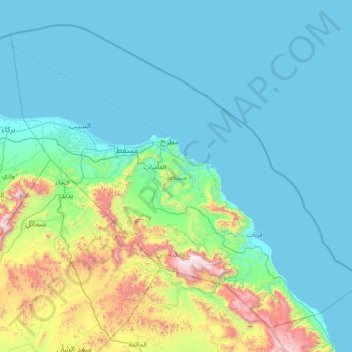
Name: Muscat Governorate topographic map, elevation, terrain.
Location: Muscat Governorate, Oman (22.89925 57.89352 24.06818 59.37531)
Average elevation: 266 m
Minimum elevation: -1 m
Maximum elevation: 1,964 m
Other topographic maps
Click on a map to view its topography, its elevation and its terrain.
Falaj
Oman > Muscat Governorate > Muscat
Falaj, Muscat, Muscat Governorate, 112, Oman
Average elevation: 194 m
Al Balid
Oman > Dhofar Governorate > Salalah
Al Balid, Salalah, Dhofar Governorate, 216, Oman
Average elevation: 4 m
Al Hajar Mountains
Oman > Al Batinah South > Ar Rustaq
Al Hajar Mountains, Ar Rustaq, Al Batinah South, Oman
Average elevation: 2,502 m