
Travis County topographic map
Interactive map
Click on the map to display elevation.
About this map
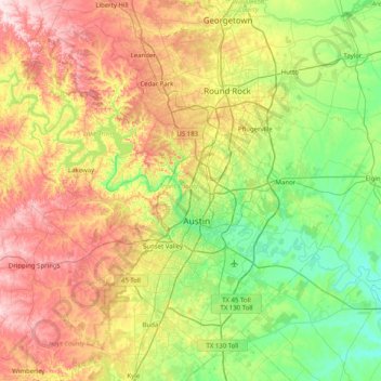
Name: Travis County topographic map, elevation, terrain.
Location: Travis County, Texas, United States of America (30.02329 -98.17305 30.62792 -97.36958)
Average elevation: 231 m
Minimum elevation: 102 m
Maximum elevation: 453 m
Travis County straddles the Balcones Fault, the boundary between the Edwards Plateau to the west and the Texas Coastal Plain to the east. The western part of the county is characterized by the karst topography of the Texas Hill Country, while the eastern part exhibits the fertile plains and farmlands of the Blackland Prairie. The Colorado River meanders through the county from west to east, forming a series of man-made lakes (Lake Travis, Lake Austin, and Lady Bird Lake). Lake Travis garnered national attention in September of 2020 as the site of a major boating accident during a Trump Boat Parade in which five boats sank.
Other topographic maps
Click on a map to view its topography, its elevation and its terrain.
Jefferson County
United States of America > Texas
Jefferson County, Texas, United States of America
Average elevation: 5 m
Hamilton County
United States of America > Texas
Hamilton County, Texas, United States of America
Average elevation: 337 m
Pecos County
United States of America > Texas
Pecos County, Texas, United States of America
Average elevation: 969 m
Clyde
United States of America > Texas > Clyde
Clyde, Callahan County, Texas, United States of America
Average elevation: 610 m
King County
United States of America > Texas
King County, Texas, 79236, United States of America
Average elevation: 540 m
Kent County
United States of America > Texas
Kent County, Texas, United States of America
Average elevation: 646 m
Washington County
United States of America > Texas
Washington County, Texas, United States of America
Average elevation: 87 m
Montgomery County
United States of America > Texas
Montgomery County, Texas, United States of America
Average elevation: 69 m
Madison County
United States of America > Texas
Madison County, Texas, United States of America
Average elevation: 91 m
Fayette County
United States of America > Texas
Fayette County, Texas, United States of America
Average elevation: 117 m
El Paso County
United States of America > Texas
El Paso County, Texas, United States of America
Average elevation: 1,267 m
Kenedy County
United States of America > Texas
Kenedy County, Texas, 78385, United States of America
Average elevation: 12 m
Andrews County
United States of America > Texas
Andrews County, Texas, 79714, United States of America
Average elevation: 965 m
Reeves County
United States of America > Texas
Reeves County, Texas, United States of America
Average elevation: 986 m
Nelson City
United States of America > Texas > Nelson City
Nelson City, Kendall County, Texas, United States of America
Average elevation: 485 m
Culberson County
United States of America > Texas
Culberson County, Texas, United States of America
Average elevation: 1,253 m
Dallas County
United States of America > Texas
Dallas County, Texas, United States of America
Average elevation: 158 m
Harris County
United States of America > Texas
Harris County, Texas, United States of America
Average elevation: 28 m